
After two red-eye flights and barely a wink of sleep, I scarf down a sausage made from reindeer meat and stare down a 9-foot tall stuffed Alaskan Brown bear in the Anchorage airport. I make my way to the gate to board yet another flight. Unlike on the other flights, I finally have a window seat, and I marvel at the amount of water here...thousands of small lakes and ponds, shimmer in the morning sun. Springy green tundra extends out in all directions and streams meandering wildly to the sea. The plane makes a quick stop in Dillingham. When the doors of the aircraft open that smell that I can only describe as wet, envelopes the cabin. Its the smell the air has after rain. We drop off a few passengers and pick up some others and take-off again heading south. We enter a cloud bank as we make our final descent into King Salmon.
King Salmon is a small town on the Naknek River near Bristol Bay. It has an airport, two bars, a military base, a convenience store, and an endless supply of bugs and cloudy days. It's the hub for getting to Brooks Camp at Katmai National Park, the place where every image of a bear eating salmon on top of a waterfall that you have ever seen was taken.
Things to do in King Salmon include fishing, swatting at the biting insects, petting little bear (the rust-colored Malamute that lives under the Sockeye Saloon), gawking at the high prices in the local grocery store, marveling at local collections of antique glass fishing floats, and taking pictures in all of the local cutouts.


A tip: if you are heading to King Salmon, just bring bags of salad, if not for you, then to sell for a premium on the street, or to share with locals and make friends. Fresh vegetables are hard to come by here, everything has to be flown or barged in. A mostly wilted bag of spinach will set you back $6.99, a soft tomato for $1.50, a bag of dried up shriveled carrots $4.99. It's mostly freeze-dried and tan-colored foods from here on out. Welcome to the land of no salads.
We have come to King Salmon for two reasons; (1) to meet with Katie, Who lives in here and (2) because flights to Port Heiden connect through this small town. Our destination is the remote and mysterious Aniakchak National Monument and Preserve. In 2017 over 331 million visits were made to National Parks, Monuments, and Recreation areas in the United States. Yet only 100, or .000003%, of those visits, happened to take place at Aniakchak. Officially, it's the least visited unit in the National Parks system.
The lack of visitation could be attributed to many things. First off, getting to Aniakchak is a logistical nightmare. It took $1200 and four separate flights just to get to the closest town, Port Heiden. And when you get to Port Heiden, there is still 20 miles of roadless bog and tundra separating you from the monument.
Another reason the crowds go elsewhere could be the weather. Average highs in Aniakchak during the summer are in the 40s and 50s. This place is perched on a narrow peninsula between the Pacific Ocean and the Bering Sea, the weather comes in from all directions. The Park Service’s website says this about the weather in Aniakchak “...most days [its] overcast and wet, Coastal areas are often shrouded in fog and rain. Winds are frequent, and even in the summer these conditions can lead to hypothermia.”. Yeah, so people probably don’t come here for the mild climate.
Among the other deterrents the sizable population of sizable bears. The Alaska Peninsula boasts one of the highest concentrations of brown bears anywhere, up to 400 per square mile, these bears can reach 9 feet in height and nearly 1000 pounds and there are no fenced in boardwalks to protect you like at Brooks Camp, or rangers to shoo these bears away. You are in their territory here, and their enormous pawprints are all over reminding you of that fact constantly. Oh... and the plants here want to hurt you too. There are fields of cow parsnip in Aniakchak. Cow Parsnip, if you didn’t know, is considered a noxious plant by the USDA. Its sap causes terrible blisters on the skin when exposed to UV light.
The park's infrastructure is comprised of precisely one cabin nestled in a field of cow parsnip with and a pit toilet with no door. So don’t expect a cozy visitors center with a movie and a place to stamp your National Parks Passport.
With all these obstacles, why go here at all? Well, in short, its wild, painfully beautiful, and one of the few places you can raft a boat on a river flowing out of an active volcano. Aniakchak is a volcanic caldera in Aleutian Range. The Caldera formed when a 6,000-7,000-foot tall stratovolcano erupted 3500 years ago. So much material was ejected from the volcano that it created a giant void, into which the mountain collapsed forming the 6-mile wide caldera you see today. The crater, over 1200 feet deep, eventually filled with water. Imagine something like Crater Lake, Oregon except way further north and crawling with Brown Bears. At some point, over 1000 years ago, the waters of the lake broke through the crater rim at a place called the gates, the violent and catastrophic draining of the lake caused a torrent which pushed house-sized boulders miles downstream.
Today, the volcano is still active--in fact, it erupted as recently as 1931. What remains of that prehistoric lake, is a much smaller but significant lake colored a brilliant electric blue. Surprise Lake, as it is known, is fed by iron-rich springs, glacial rivers, and snowmelt. The outlet of the lake is a river which flows out the side of the crater to the Pacific ocean. Our goal is to hike to the river and paddle it to Aniakchak Bay.

https://www.nps.gov/ania/planyourvisit/maps.htm

The sap of this plant can cause terrible burns if it interacts with your skin under UV light. Image from https://www.pinterest.co.uk/pin/488851734542938915/?lp=true

https://www.outsideonline.com/1924416/baked-alaska-surviving-aniakchak-national-monument
After a late arrival in King Salmon, I frantically re-pack my luggage from three big bags down to... well, one really, big bag. We grabbed breakfast at Katie’s then rush back to the airport to find out two things. First, that our flight is delayed 4 hours; and second, that we are not permitted to bring the bear spray, or camp fuel onto the commercial flight to Port Heiden. The lady at the ticket counter suggested bear bells, we all had a good laugh about that and tried not to think about getting mauled by bears.
--Pro-tip: Bear bells don't work, all they do is make other hikers laugh at you. Instead just talk while you are hiking. The human voice is far more effective at alerting bears than a bell. Also, if you can, bring a gun. We wish we had a gun, but we do not.
Once in the air, in a small 10 passenger Cessna, we start to see the rugged coastline. Braided streams cut serpentine paths through the endless expanse of tundra. Snow covered peaks are visible in the distance, the backbone of the Aleutian chain, a ridge of volcanoes stretching for thousands of miles towards Russia. Our crew for this adventure is made up of: Kory K., a geologist from Flagstaff, AZ, hiking guide, and foremost expert on the elusive Grand Canyon Manatee; Maren M., a Geologist from Austin, TX who boasts a strong passion for instant mashed potatoes; and Katie J., a hydrologist working for the Southwest Alaska Inventory and Monitoring Network in King Salmon, AK, she is famous for her elaborate baked dishes, custom knitted sleeping masks (crucial in Alaska where it does not get dark in the summer) and her ability to slurp tea louder than any human being on earth.


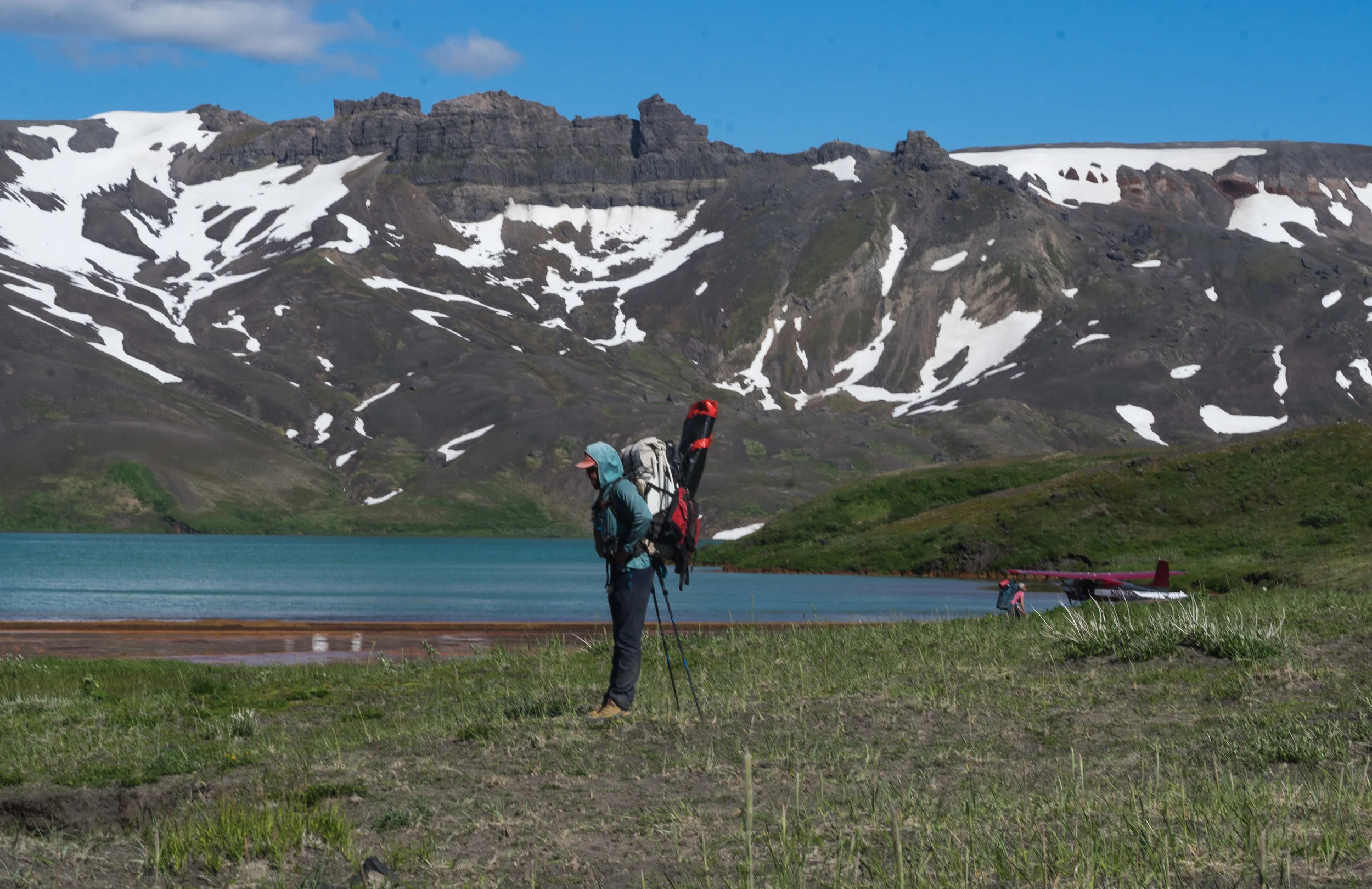
When we finally touch down on the gravel runway in Port Heiden, our local guide Kris Carlson is waiting for us. He picks us up and squires us back to the charming bed & breakfast that he owns-- Carol's Legacy Lodge. He feeds us salmon caught the day before, along with a side of tomato soup. We strap our gear onto a couple of ATVs and hold on as Kris, and two other local guides drive us across rivers, bogs, through alder thickets, and up cinder hills to get to the edge of the national monument tens of miles away. Hearing about our trouble getting bear spray and fuel onto the plane, Kris gives us some white gas he had lying around and provides us with an expired bear spray and an air horn. We are elated.

(Photo by: Katie Junghans)

(Photo by: Katie Junghans)

"Kris" Kristian Carlson on the rim of the Aniakchak crater, Kris is the local guide who provided us with lunch, a ride from the airport, and an ATV ride to the edge of the monument.
We spend a quiecent night on the rim overlooking Surprise Lake, snow drifts, and lava flows a thousand feet below. The sun lingers in the sky over the Bearing Sea, and we scramble around the nearby high points to take in the view, it's 11:30 pm before it finally sets behind the clouds. At this angle, the sunsets are more brilliant and last longer than I am used to. The vibrant band of lavender, bordered by pink sometimes called the belt of Venus is visible. The deep purple-blue band is actually the shadow of the earth as the sun slowly dips below the horizon. The show lasts for over 30 minutes and paints the far side of the crater with a majestic rosy hue.
camp on top of the crater rim

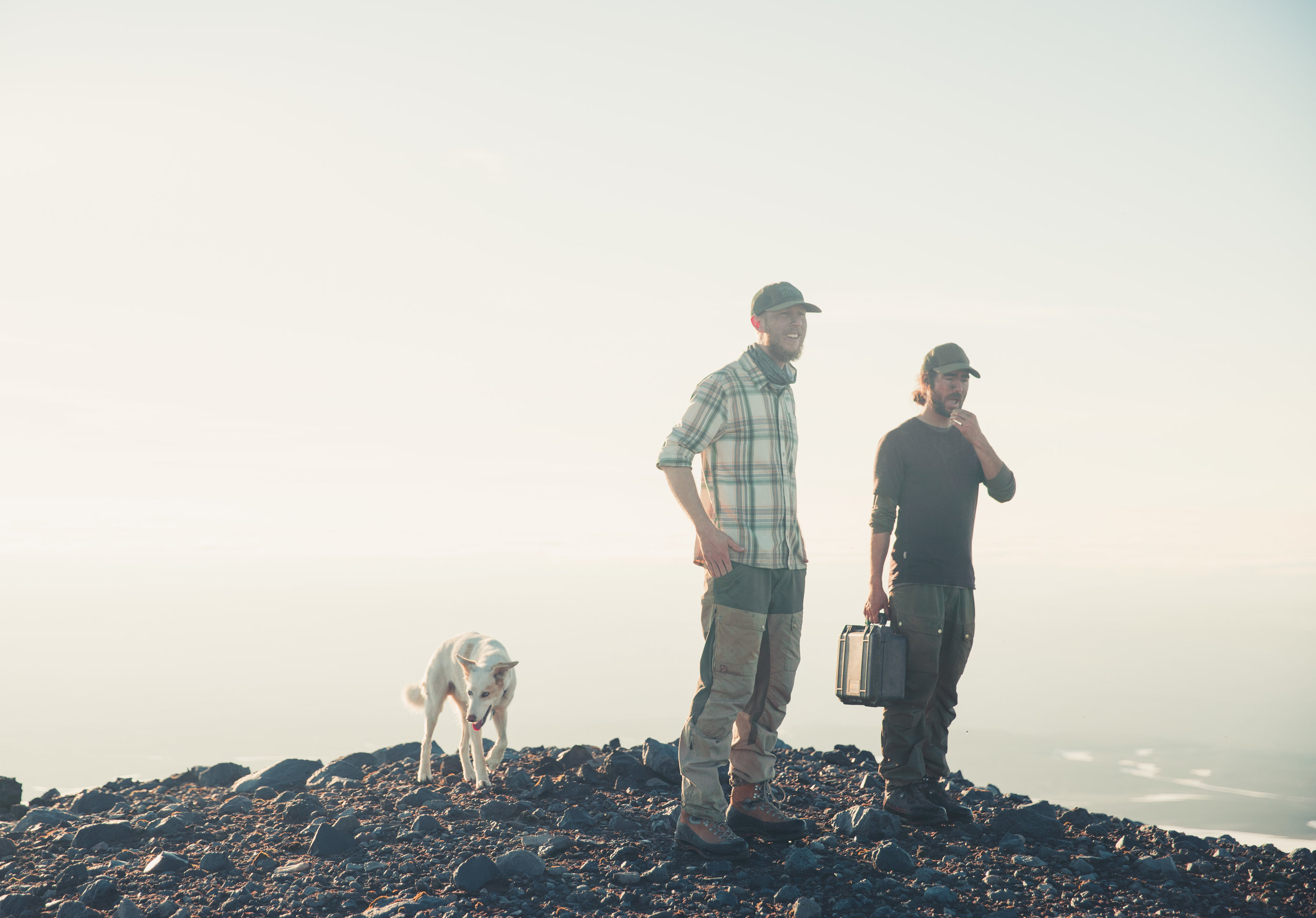
Two brothers from Utah and their dog. We share camp with them at the rim.

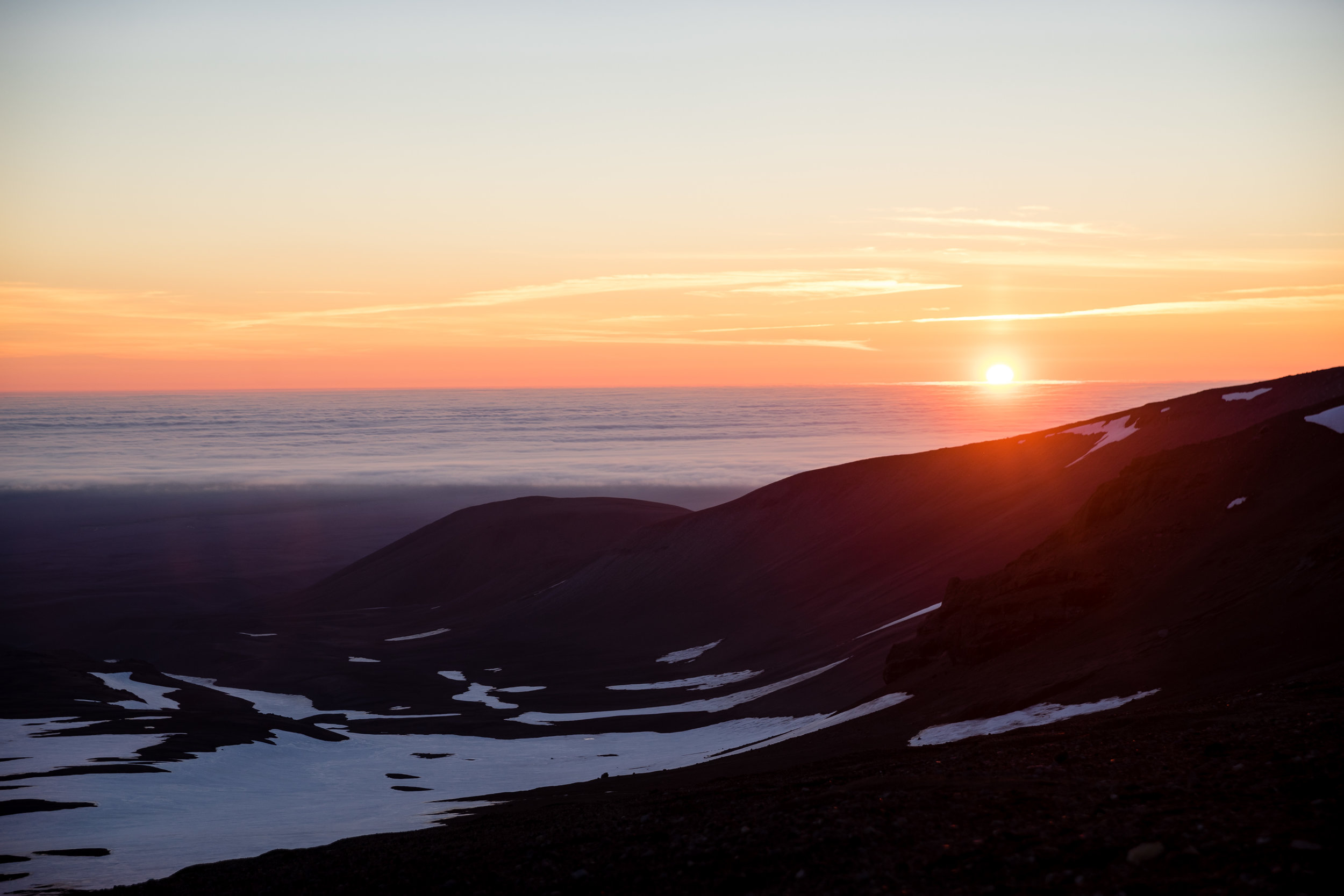
Sunset July 1st 11:25 pm looking back towards the Bearing Sea from the crater rim

The belt of Venus is visible behind Maren. All our faces were caked with dirt from the ATV ride up
The next morning is remarkably calm, we wonder how we could be getting so lucky with this weather. We then wrestle our obscenely large packs onto our backs and descend the steep slopes into the crater. Gliding over the ciders, scree skiing, we make good time. We stop only to dump loads of lava rocks from our shoes. We plan to spend the next three days exploring the crater, then begin our river voyage.
On the first day, the weather was splitter. We found a sparsely vegetated moonscape. Ridges of sharp lava are frame rolling hills of loose cinders. It looks mostly barren, but a careful eye will notice patches of moss, lichen, cryptobiotic crust trying to recolonize the crater. Lupine, stalks of lavender colored wildflowers in the pea family, find purchase between gnarled sculptures of sharp lava rock. Caribou roam and seek refuge from the summer sun on the snow drifts. Rust colored warm springs pour into Surprise Lake. Warm enough to bathe in, the springs are rich in heavy metals and leave the skin smelling like old pennies. We see bear sign all around us, large prints, scat, piles of salmon bones near the lake shore, these signs keep us on high alert.
We expected to see bears, but they remained elusive. What we did not expect to see though, was other people. However, two floatplanes landed on Surprise Lake while we were there, no doubt taking advantage of the clear skies and amicable weather. We also ran into a total of 15 other people including two separate groups of packrafters during our three days in the crater. I would venture to guess that over half of the annual visitors to this place come in July. By the morning of the second day, our pleasant weather begins to turn. Clouds pour over the crater walls, and the wind picks up. We spend the day looking for a camp with more shelter from the wind. We find a small protected canyon with 4 large springs spouting straight from the rocks near the outlet of the lake. We all agree that this is the best camp spot of all time. We camped there, and Katie manages to catch a pink polka-dotted fish for dinner. She say's its a Dolly Varden, and we boil it with some couscous and dehydrated vegetables. We take our meal behind a large outcrop of lava rock, protected from the wind, on a bluff above camp with stellar views of the lake below. The wind is now howling over 40 miles an hour we guess. After dinner, we share some bourbon, carefully stake out our guy-lines, then drift off to sleep.


Scree slope descent into the crater

Wildflowers on the way to Surprise Lake

Caribou can be seen roaming around the inside of the Crater


Our perfect little camp spot.

On the third day, the sun and clouds battle, sunny warmth is periodically broken by bitterly cold winds. We ascend the fog-draped vent mountain, which Rises over 400 meters above the crater floor. It's Independence Day, and in the absence of any firework displays, we spend the afternoon dislodging boulders and trundling them down the snow-covered slopes of vent mountain into the vacant crater within a crater. Our hoots and hollers can be heard for miles echoing off the walls, we are a force of erosion.
Usually, I do not advocate trundling. In the crowded Grand Canyon near my home, it's reckless and irresponsible, too many people crawling all over that place. But here, at the lonely margins of our continent, there is less risk. Most of the rocks we are scrambling over are less than 100 years old, ejected from an eruption in 1931. Any day now an increase in volcanic activity could re-shape this place entirely, so we reason that its alright. After circling the rim vent mountain, we bomb and butt-slide down the snowfields and head back to camp.

On the top of vent mountain


A smaller lake we spotted from the top of Vent mountain fed entirely by snow.

The next morning we wake up to gray skies and clouds pouring into the crater. Hot tea and coffee make the rain and cold slightly more tolerable. We pack up camp and head to the lake. We load our gear into the T-Zips of our pack rafts. These watertight zippers allow us to carry our camping gear and food inside the boat rather than packed on top. Within a few minutes, the boats are inflated, and we are on our way into the gates.
The placid lake gives way to a rushing river. The first couple miles of the river drop at a rate of 75 feet per mile, a very steep gradient. We eddied-out about a quarter mile after putting in. We hear the crashing water which we can only imagine is the gates. We find a giant boulder garden in front of us. It looks very different from the 1990s images we had seen showing oar rigs bouncing down between a couple widely spaced rocks the river. The river is choked with enormous stones. Strong current surges between and underneath sofa-sized boulders. The lines look reasonably complicated and high consequence. One would probably have to memorize a long sequence of tricky moves to make a go of it. Most paths are too narrow for even a packraft. Kory runs the first 100 yards of rapids, and we walk along the shore to set safety. Kory makes it through the first bit but eddies out before a scary looking sieve. We portage down the left bank a bit further, maybe 500 feet, before I work up the nerve to put in. I hit the first drop then make a wrong turn which forces me to squeeze between two rocks, but the slot is too narrow. My right tube rides up on one of the rocks, and I get dumped into the frigid knee-deep water. The raft slips from my wet, cold fingers and floats down some impressive rapids without me, Kory jumps from shore and grabs my raft.
I made the mistake of letting my bear-resistant food barrel get too far forward in one of the tubes and the combination of the hard plastic inside the boat and the sharp volcanic rocks on the outside led to several small holes in the raft. With the help of the throw rope, I swim the half-deflated raft across the river to portage the rest of the gates on the right side. The others portage past a few more large drops and put in just below. They float a few miles to camp while I hike the shore.
I spend the windy evening repairing the small holes in the boat with tenacious tape and aqua seal, wishing I had brought the Cotol-240 accelerator and some Tyvek tape, I'm left with no choice but to wait the 8-12 hours for the aqua seal to cure. A cold, damp night passes but in the morning the boat seems to hold air! This time I load the bear can in the boat wrapped my foam sleeping pad and keep it near the back of the boat.
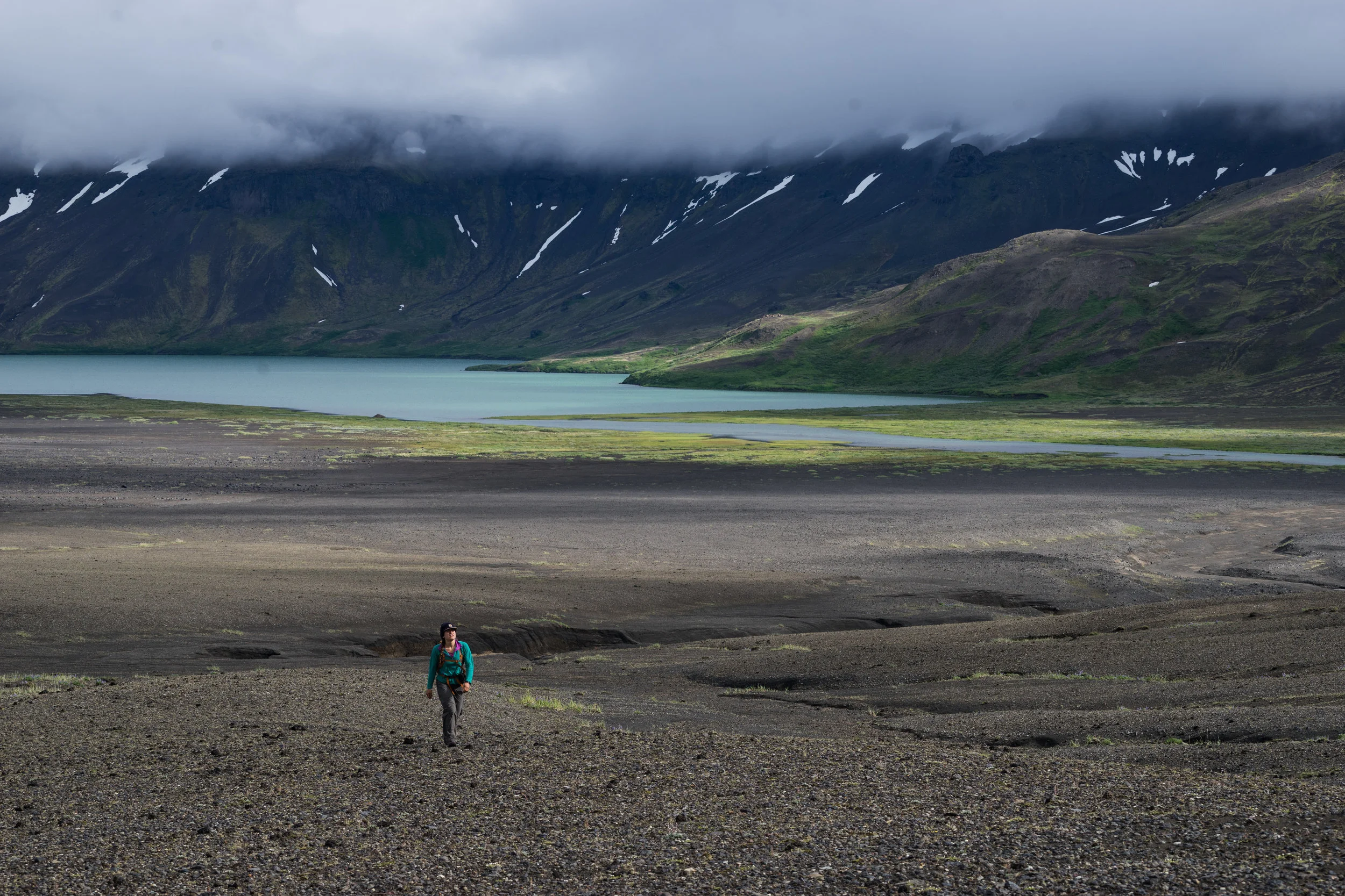
The low clouds and fog which appear to be the rule rather than the exception on the Alaska peninsula begin to burn off as we start paddling. The weather here is genuinely unpredictable. The river for the next 10 miles is fast and fun class II and III through Hidden Creek. We had heard that the Hidden Creek could be troublesome but with slopes thick in cow parsnip we elected not to scout and just ran everything. There are a few significant drops but mostly just fun whitewater. Rocks and shallow cobble bars keep you on your toes always. After Hidden Creek, the river begins to braid forming an anastomosing channel. Alder crowds the bank and the channels are both narrow and shallow, vigilance is needed to stay in the thalweg and keep from scraping bottom on a cobble bar or getting swatted by overhanging alder branches.
We paddle until the river gradient mellows and the water begins to slow. The river widens and starts forming large meanders. Ample point bars provide great camping. We choose to camp near the confluence with Mystery Creek. The sun comes out, salmon are jumping in the water. Katie tries to land one, but ends up with another Dolly Varden. We cook the fish in foil over a fire of alder branches and driftwood. We see enough bear sign that we break out the bear fence. The fence is a few poles and 3 spools of wire hooked to two D batteries. It provides a small static-like shock which apparently is enough to scare away a 800-pound salmon slaying monster, but I am skeptical.

photo by Katie Junghans


The Gates, some park rangers told us that recent rockfall has changed the gates over the past few years.

Katie standing saftey as Kory picks his way through the boulder garden at the start of the gates. Vent mountain looms in the background shrouded in fog.


The next morning it’s cold and misty, all the clothes that I had put out to dry in the evening sun the night before are soaked. I once again put on my drysuit and load the boat. I realize that the dry suit is only mostly dry, evidenced by my perpetually wet socks. We paddle directly into the wind. The flat water, endless meanders, spitting mist, and the headwind make the day long and arduous. Arctic Terns show up and start diving all around us. We chase a few Bald eagles with our boats, when we get close they pick up and fly further downstream showing us the way.
The bluffs on the cutbank side of the meanders can be rather steep and tall, claw marks from bears can be seen on some of these banks where bears recently tried to get out of the channel. This adds fear to the gloom we already feel from the weather and unrelenting wind. Finally, after 8 hours of paddling we reach shallower waters, the smell of salt in the distance and clouds of seagulls can be seen gathering. Sedimentary rocks push up at odd angles creating large cliffs, black sand beaches lined with driftwood and grasses are visible. We have finally reached the estuary. Rock outcrops line the coast and large groups of salmon gather and jump.
We round the corner and the ocean waves begin to push on our boats. We unload and see some giant bear prints and search for the cabin which the map says is near. We pass between two bluffs each with a bald eagle on the summit, and we see a group of people in bright jackets gathering muscles from the rocks.
A group of people was the last thing we expected to see, but these were scientists on an expedition to study the sedimentary rocks which just appeared where the river met the ocean. They were on the search for the footprints of Duckbill dinosaurs. They point us to the cabin tucked on a vegetated bench just up from the beach. A small creek wraps around the cabin and forms a moat out front until it's waters mysteriously disappear into the sand. They let us stay in the front room of the cabin, which is mostly used for storage. We do our best to dry out our clothes soaked during the 8 hours of wind and rain we just paddled through.


The estuary after a long, cold, windy, rainy day of paddling flatwater


Columbia Packers Cabin, generally left open for use by whoever happens to make it here

A mother bear with two cubs, scrounging for fish on the beach.

The inside of the cabin is rather cozy with a new wood stove
The next morning we awake to grey clouds, a low ceiling, and high winds. We are anxious that the weather is too crappy for our bush pilot to pick us up. We pack, and then we wait. In the cabin we find old logs describing trips down Aniakchak where 30+ bears are seen. We haven’t seen any, that is, until Maren visits the pit toilet and sees a mother and two cubs up on the hill nearby. I watch them wander off the hill and down the beach searching for whatever the last tide brought in.
The weather is changing rapidly, it seems okay for a few hours then a fog bank rolls in. The logbook describes people waiting days for a pickup. Nearing the end of our food supply we, anxiously watch the skies.
In the cabin we find old pictures of Aniakchak crater, some show the gates with far fewer rocks than we saw, confirming our suspicion that more large rocks recently made their way into the gates. The shelves are full of trinkets, and used up fuel canisters, we find a book called “Where the Sea Breaks its Back”, by Corey Ford. This book describes the journey of Captain Bearing and a naturalist named Steller who ventured to Alaska and described hundreds of new species. I find out that the Stellar Jay, familiar to my home in Flagstaff was named after this guy. The book describes the wild weather and rugged beauty found in the Aleutian range. The following quote sums it up quite nicely…
“The name Alaska is probably an abbreviation of Unalaska, derived from the original Aleut word agunalaksh, which means "the shores where the sea breaks its back." The war between water and land is never-ending. Waves shatter themselves in spent fury against the rocky bulwarks of the coast; giant tides eat away the sand beaches and alter the entire contour of an island overnight; williwaw winds pour down the side of a volcano like snow sliding off a roof, building to a hundred-mile velocity in a matter of minutes and churning the ocean into a maelstrom where the stoutest vessels founder.” - Corey Ford
This squares with the wild weather, winds, and waves we have experienced in our short time here.
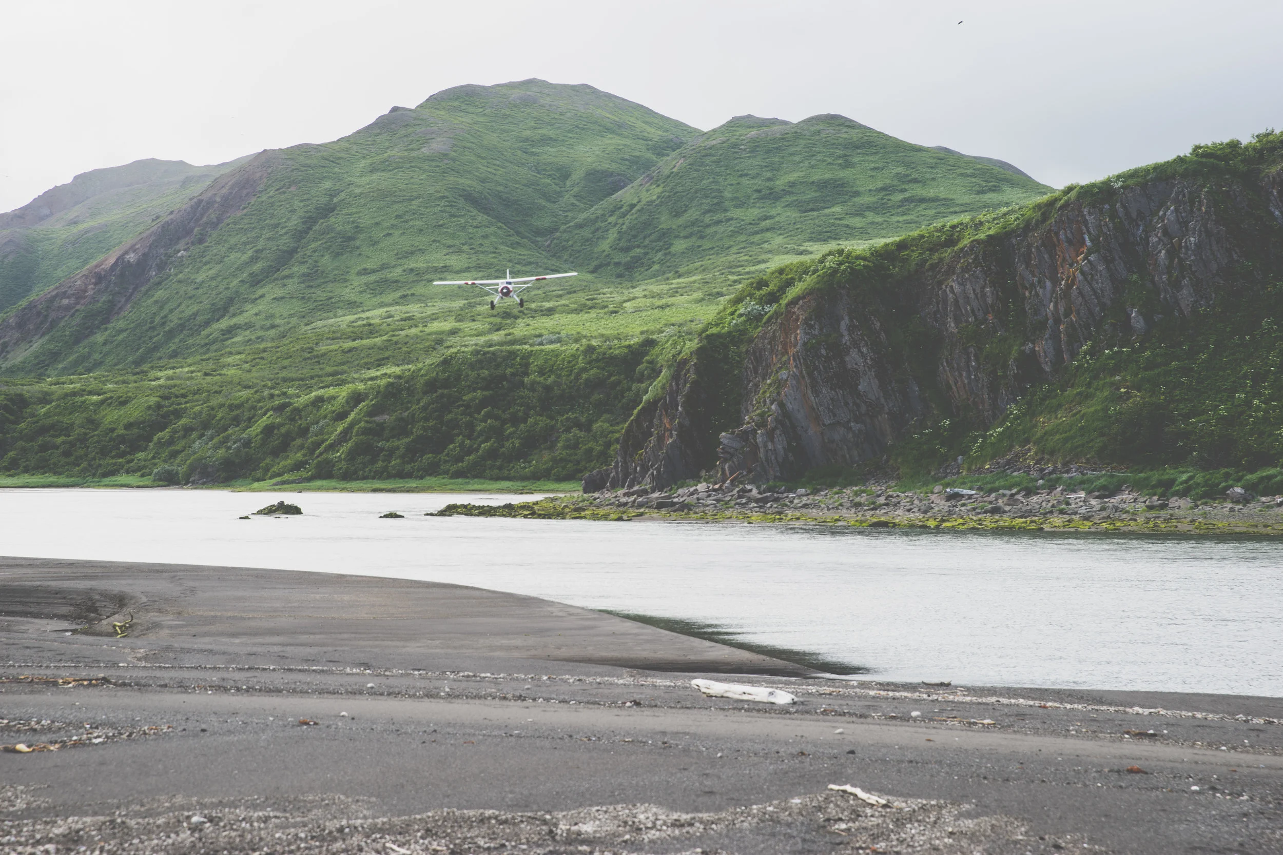
At around 5:00 pm we get a call on the sat phone that there may be a chance that we can get picked up, the ceiling appears to be slowly lifting, and some blue sky creeps through. We hurry to sweep out the cabin and shuttle our things to the other side of the river to the bigger beach more suited to landing a bush plane. We ferry our stuff across the mouth of the river just as we hear the de Hallivard Beaver pierce through the clouds. Chris from Trygg air sticks the landing and touches down on a small spit of sand directly in front of us. We jump in and start moving, the runway is short, 400 feet with lapping waves ahead of us, but we face the wind, and the wheels leave the sand just 20 feet short of the waves. We made it out!
As we fly back to King Salmon, we get one last peak of the volcanic crater we just paddled out of. We can see the endless meanders we struggled through, and the snow peaks whose meltwater we rode to the sea. We did it all and escaped without being mauled by bears, drowned in rapids, burned by noxious weeds, or demoralized by the weather. This was the trip of a lifetime --remote, wild, logistically complicated, and stunningly beautiful.

Chris from Trygg Air picks us up in his de Hallivard Beaver which lands directly on the beach

The seemingly endless meanders section viewed from the plane
